The Water linked UGPS is an external positioning system that is providing the position of the ROV by using 4 transponders topside, and one mounted on the ROV. In our setup this is the U1 Locator. The U1 is self contained, wireless, with its own battery, so it can also be used together with the Blueye Pioneer or Pro models.
Install the U1 Locator
Setting up the positioning system
- Make sure to have updated Blunux to v 3.1.52 or newer and that you have the latest Blueye app installed.
- Find a way to properly mount the Antenna to the floating dock or your boat. It's recommended to use the RAM system to get a solid mounting.
- Connect the Antenna cable to the "Antenna" port on the Topside unit.*
- Open the box and connect the PowerBank to the USB-C connector inside and click the Power button on the side to power it on.
- Wait for about a minute for it to boot and set up the wifi. (Once you see the Ready light go green, you should be able to see the UnderwaterGPS wifi).
- Align the topside unit arrow with the arrow on one if the arms of the antenna.
- Continue with the steps below to connect the WL UGPS positioning system to the Blueye WiFi network.
* You can also use the loose transponders, but then the distances must be entered in the WL web GUI. Read more in the Water Linked Quick Start Guide for more advanced settings.
Connecting the WL Surface unit to the Blueye Surface unit
In order for the ROV to know the position provided from the UGPS system, they need to be on the same network. This is possible by going to the WL web interface while connected to the "Underwater GPS" network. Under Settings you'll find "Advanced settings" and "WiFi configuration".
Select "WiFi Client" and enter the SSID (Blueye_xxxxxx), password (1234567890), and hit "Apply".
Make sure the Blueye surface unit is powered on before you hit "Apply". Switch over to the Blueye Wi-Fi network and you should be able to enter the Water Linked GUI on http://waterlinked-ugps.local. This page can also be used to display the ROV position while diving, if you want to have the map on a different device.
Pro tip: To get the map showing in the WL GUI you need a device with a 4G/5G connection at the same time as it is connected to the Blueye WiFi.
Changing settings from the Blueye App
When this works you can just power on the drone and you should be able to see a new tab in the settings menu called "WL UGPS". The drone will automatically detect that a UGPS system is available on the network.
In this tab you can se the status of the UGPS system and configure the most frequently used settings.
Every time you use the system you need to set the initial heading of the topside unit, (and reset the gyro if it seems to be drifting). You can either use the compass from your device or type a manual heading offset to set the topside units orientation directly from the app. You can also read the current heading of the topside unit as shown in the lower left corner in the screenshot above.
Make sure the power on the U1 and wait for it to get GPS lock (which is indicated with a solid green light), before you put the drone in the water.
As soon as all status messages are green in the WL UGPS tab, you should start to receive position data in the Navigation tab.
Export a position track to KML or KMZ
All dives with a DVL connected will have a position track in its dive log. Click end dive, transfer media files, and sync the log files. Find the relevant dive in the dives tab and open it. Now you'll see a map showing where you have been during that dive. All the images taken during this dive will also have the position data included automatically.
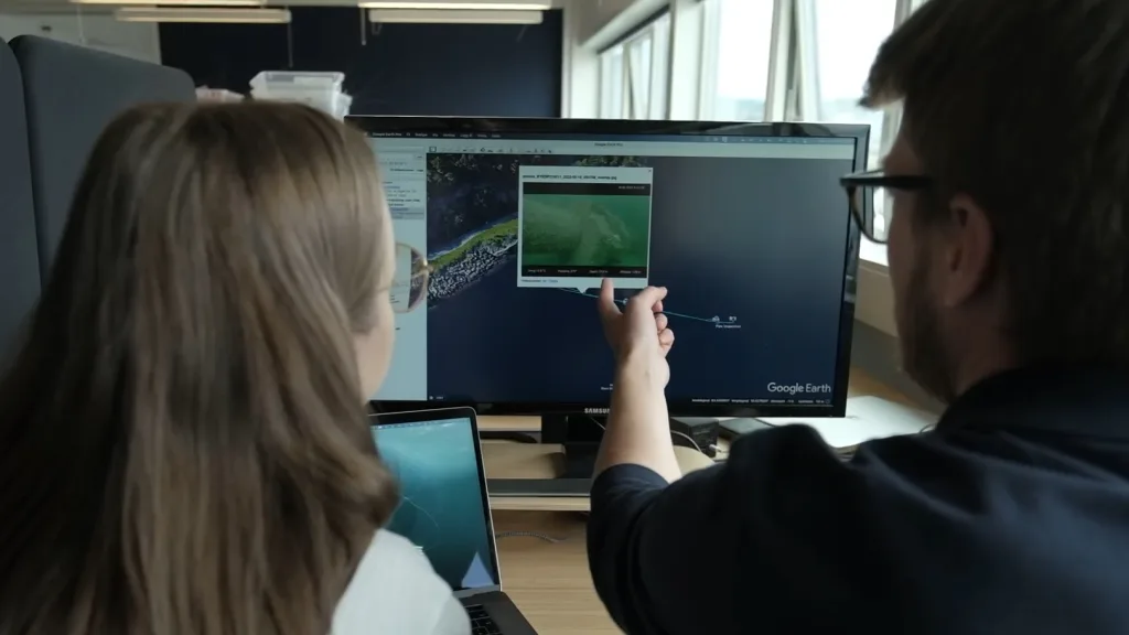
Find the share icon in the top right of the screen and select Share as KMZ. The app will now generate a file that contains the position track and the images captured during the dive. This file can then be shared via Airdrop, e-mail or in a text message. You can also open it directly in Google Earth if you have that app installed on your device. KML is also an option that does not contain the images and is therefore smaller in size typically.
The position will also be available in the CSV file, which can be generated in the same way. The CSV file will contain WGS84 Decimal degrees together with other relevant dive data.
Comments
0 comments